Fear and Loathing on the Columbia River

After departing Portland, my husband, Simon, and I embarked on what would otherwise have been a two hour drive to our next stop: Astoria, Oregon.  We were pulling into the home stretch of the Columbia River’s journey to the Pacific now (and, thus, that of the Lewis and Clark Expedition).  Having followed hundreds of miles of the expedition’s river routes over the past year or so, my journey was also nearing its end.  I was overwhelmed by a need to see as much of the Columbia as I could on the way to Astoria in order to really savor the final leg of the adventure.  Unfortunately, the river flowed through quite a rural area here and was therefore not visible from the highway the majority of the time.  We were about fifteen miles from where the Columbia finally turns into an estuary, so, wanting to get a last look at the river which had borne the Corps such a long way, I drove off down a road though farmland.  I blindly headed north for several miles, knowing we would eventually meet up with the river somewhere.

After a while, a sudden parting of the trees revealed an expansive sandy ridge with an ENORMOUS CONTAINER SHIP gliding along on top of it only a couple hundred feet away from us.  I’m from un-beach-savvy Colorado, so this completely threw me for a loop, and immediately the car was lured off the road and out onto the sand.  The thought of a ship of such immense size passing so close to the bank of a mile wide river (to avoid islands, it later turned out) pretty much caused me to have an out of body experience.  A little voice (which sounded suspiciously like my own) commanded me to drive to the top of the ridge, park, and let the drool dribble freely from the amazed mouth I was no longer able to close.  Eager to obey, I proceeded to drive the car about 100 feet out into the sand, where it promptly plowed its way to a stop.

The majestic Columbia River is barely visible beyond the expanse of sand, while Washington state lurks on the other side of it.
Note the small pile of dead leaves we have placed under the rear wheels in some futile attempt at traction.

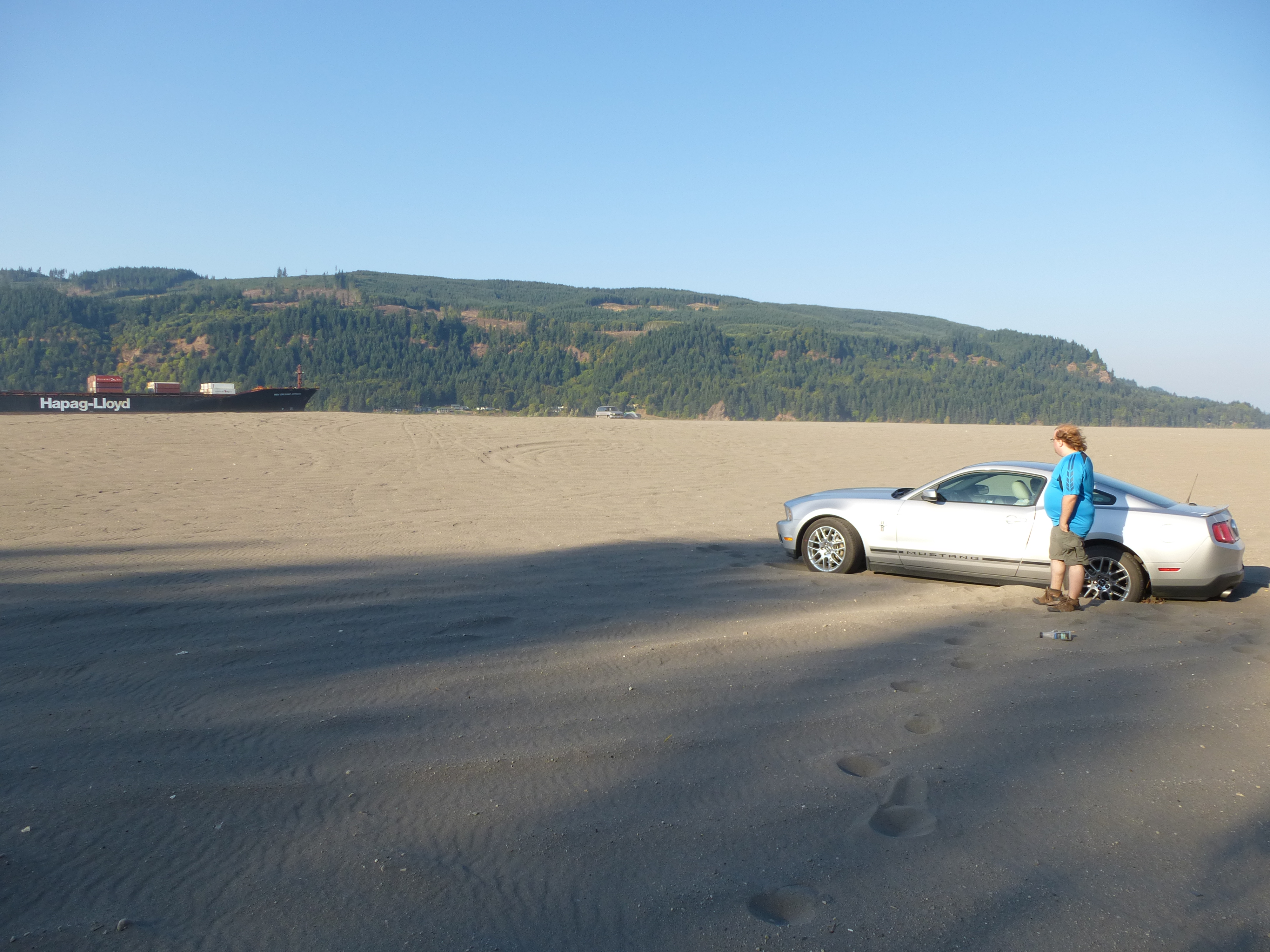
As we got out of the car to assess the situation, I soon found out the secret ingredient behind sandy ridges with wide views: their exposure to constant, lashing wind.  We stepped out into the sandstorm, barely able to see, function, breathe, or communicate.  We took turns braving the elements and trying to dislodge the car while the other one attempted to drive it forward or backward or, rather, get it to move even an inch.  We had to keep the driver’s side window cracked to even attempt to hear each other, so sand blew in and covered all our possessions and started mounding up about half an inch deep in the back seat.  The car would not budge and was beached up to the axles.

Needless to say, it was not a good look for our silver, late model Ford Mustang rental car.  We had originally arranged to rent a cheapo compact car for our vacation but, “Nooooo!” the lady at the rental agency had said on our arrival, “You want something ‘fun to drive’ for your special trip!  It will only be $10 per day extra!”

We prayed to whichever gods were tasked with babysitting dumb tourists.  Nothing happened.  A sacrifice seemed in order, so we placed my beach towel under a rear wheel of the car.  The wheel spun helplessly and destroyed the towel.  We wedged Simon’s flip flops under the rear wheels and tried to get the car to move.  It would not budge.

We had been so distracted we had missed getting to look at the ship, and it was long gone.  To add insult to injury, by this time it had dawned on me that the Columbia River, at this proximity to the Pacific, was now tidal (Lewis and Clark had even remarked on it).  And the car was right by it.

Looking out at an island in the Columbia River during our quest for civilization.

A half hour later, we gave up and started walking down the road, wondering if we would ever see the car and our possessions again.  I quit smoking three years ago, but would have chain smoked every cigarette in a pack, had I had one.  Simon’s fancy cell phone had no signal and my ancient one (which is such that I basically have to wait for a stonemason to come chisel my text messages) didn’t, either.  I knew that we were about 30 miles away from both Astoria, Oregon and Longview, Washington (in opposite directions), but none of that really mattered considering we were miles from even the nearest hamlet.  I sulked down the country road for a ways until my phone, on its final flashing bar of battery and with less than five minutes of pre-paid time remaining, finally got the vaguest of signals.  I called my car insurance and jabbed repeatedly at the “zero” button until I got hooked up with a choppy connection to a lady I pictured as being in a call center in Cincinnati, Ohio.

“Do you mind if I ask you a few questions in order to provide you with the best service possible?”

“Um, well, you see…”

“Are you and your car in a safe place right now?” she carried on.

“Yes.  Um, well, it’s stranded on sand on a remote, tidal beach in a rural area and I have five minutes of cell phone time left, three of which I have used getting through your automated menus,” I replied (at least in part).

“Where are you located?” she asked.

“Um, I’m next to the Columbia River, near umm…” I trailed off, recalling that the Columbia starts somewhere in Canada and I was basically near the northwest most point of Oregon, “Marshton?  Uh… Marsh…dale?”

“I can’t seem to find that.”

“Uhhh, well, we passed a tiny town a ways back on the highway.  What was it, Simon?  Uh, I should have paid more attention.”  At a complete loss, I started stringing together promising-sounding fragments of Pacific Northwest town names, “Uhhh, Skanatamia?  Skintasie…? Scocsalosie…?”

“How do you spell that?”

I spent the next thirty precious seconds participating in the most important spelling bee of my life.

“I’m sorry, but I’m not finding those, ma’am.”

“Well, I KNOW we’re kind of near Astoria, Oregon…”  (Thirty miles away, ahem.)

The signal was continuously breaking up and we could barely hear each other, anyway, so the phone decided to call it quits on our quasi-emergency rescue.

What are YOU lookin’ at, osprey?
Roll on Columbia

Simon and I carried on walking down the country road.  It was a beautiful place to be stranded in, with a golden sunset streaming across the green fields, distant hills beyond them on our right, and the river peeking through the trees on our left.  The rapidly setting sun highlighted the red and yellow apples on nearby fruit trees in a charming way, as it did the barbed wire and the (presumably poison) ivy along the road.  I began to think the powers that be were gifting me with a small slice of adventure in order to put me closer in touch with the perils endured by Lewis and Clark’s party.  I even started to fantasize a little about the possibility of having to sleep on the beach next to the Columbia.  Maybe we would even get attacked by a grizzly bear and, in a heroic act similar to those of Lewis and Clark, I would throw my disabled cell phone at it and it would fall down dead!  Perhaps we’d then even get to try grizzly bear stew and…

Simon, meanwhile, was mainly upset that technology had failed us in pretty much every possible way, and was storming silently down the road, fists balled at his sides.

I tried my hand at some humor to lighten the mood: “Honey, I think now is an appropriate time to let you know that, if I die, you have my permission to eat me in order to keep yourself alive until you reach Skuccapaloosa.”

He was not amused.  Someday, he would look back on this and laugh.  Someday, perhaps twenty years after you read this.

Exhibit A: Sandy Beach of Doom

The shadows of the trees stretched ever longer across the road and, after walking about two miles, we finally came upon a farm house.  The clinks of the wind chimes on its porch were about the only sounds in the surrounding rural quietude.  An errant cat slinked by in the yard.  Simon and I hesitated, urging each other in sharp whispers to be the one to act as spokesperson.  That dirty deed, of course, fell to the one who got us in this mess.  I walked gingerly down the path to the front porch, followed by a reluctant Simon.  We were careful to not disrespectfully step on so much as a blade of grass.  As we climbed up the stairs, I heard the TV going in the front room.  I nudged and hissed at Simon in a last ditch attempt to get him to ring the doorbell and do the talking, but had no such luck.

A middle aged Native American man in a plaid flannel shirt and jeans came to the door, with a suitably guarded look in his eyes.  Don’t get strangers much ‘round these parts, I expect.

“Hieeeeeeee!” I blurted out lamely, but with as much cheerfulness as I could muster in case he had his rifle at hand.  I could smell grizzly bear stew cooking somewhere in the depths of the house.

“I am so, SOOOOO sorry to bother you, sir, but I got my car stuck in the sand a couple miles down the road and neither of our cell phones are working,” I explained, thinking to myself, “Wait, do they know what cell phones are around these rural parts?  Did that make me seem like too much of a city slicker?  I’m not wearing anything which smacks too much of haute couture, am I?  Oh wait, nope, just a sand encrusted t-shirt and jeans.  Good.  He’s used to being sand encrusted.  Yes.  Why, I blend right in.”

“Could I please use your phone to call my car insurance?  It’s toll free!” I said reassuringly.

He looked from me to Simon and back to me, as if he wondered just what the two of us were going to steal from or try to sell him, then closed the door.  He came back a minute later with a cordless phone, handed it to me and shut the door again.  I got back on the phone with my insurance.

“Hi!  It’s me again!  I’m the one who’s stuck in sand in Oregon!”

Apparently, call centers have more than one person working in them and this new person knew nothing of my plight.  I had to explain the whole thing and answer the whole barrage of questions all over again.  Dumb as I am, I even repeated my whole spiel about, “I think we’re near Skanatamia or somewhere!” again until I got the bright idea to summon Mr. Farm Man, ask for his address, and pass that along to the rep.

“You haven’t met your deductible yet, so there’s a $160.00 charge for this which will need to be pre-paid by credit card,” she informed me.  I think I would have agreed to anything up to about $2,000.00 before walking 28 more miles or asking for a ride from Mr. Farm Man, so I hastily forked over my credit card details.

After the call ended, I knocked on the door so I could give the phone back.  To my relief, a little boy of about eight came to answer it this time.  His Wii game was paused on the TV and I was pretty sure there was a trickle of grizzly bear stew running down his shirt.  I gave him the phone, thanked him profusely, and pressed three crispy dollars into his other hand.  Then Simon and I hightailed it down the road a ways, just far enough so that the barn was between us and the house.  That way, we were out of sight and could be ashamed in private.

I stared at this barn for, like, 2 hours.

We stood by the side of the road watching the sun sink behind the hills and the sky filter through increasingly darker shades of blue.  The family’s horses came trotting over to the barbed wire fence next to us, looking for food, but soon went away disappointed, pouting behind the anti-sand face guards they wore.  An hour passed and we still waited, looking constantly in all directions, not knowing when or from where the tow truck would be coming.  We didn’t know if they would even be able to find us out here, and we would never know if they were having trouble, anyway.  We were supposed to be staying at a bed and breakfast in Astoria that evening, and I was wracked with guilt thinking back to the reservation I had made.  I had spoken to the owner, who had informed me she was a wheelchair bound lady in her nineties, and that she would be locking the B&B up promptly upon her bedtime of 8:00pm.

A car (the first vehicle we had seen) started coming down the road, and we threw ourselves into a charade of brisk walking so as not to look like forlorn, stranded Coloradoan tourists.  The car slowed down as it approached.  It was a long, trundling 1970s car of a macramé colored brown and orange; the kind of car you expected to transform into a low rider at any moment.  We tried to look confident and local.  The 50-something driver rolled down his window.

“Hey, my mom’s been missing since ten this morning.  You haven’t seen anyone walking around here, have you?”

“Um, nope!  We’re just out for a walk, ourselves!” we said, oh-so-convincingly.  (Please don’t kidnap us and put us in the trunk with your mother.)

But then I remembered that, somewhere in the excitement of seeing the container ship, we had seen an old woman wandering around aimlessly, all alone.  We had been slightly concerned about her being out in the middle of nowhere, particularly upon seeing her sauntering along with an empty, inane grin on her face.

But hey, man – giant container ship.

I relayed this information to the man (in a more polite fashion) and he thanked us and drove off.

We resumed waiting another half hour or so in the gathering dusk until finally I saw a bright red tow truck far across the fields, spewing up dust in its wake.  WE WERE SAVED!  We stationed ourselves in the middle of the road and flagged the driver down.  Our savior had come in the form of the very gruff and to the point Phil, of Nottobenamed Towing, based in Longview, Washington (or at least the patch on his shirt introduced him as such).  My heart soared with relief.

Yep, still there.

He drove us back to where I had taken the car on its off road adventure, and got out of the truck.  Phil’s baseball cap indicated he was an ex-Navy serviceman.  From under it, his blue eyes surveyed the wind-whipped expanse of sand, our rental car marooned pathetically in its midst.  An astounded whistling noise escaped from his pursed lips.

“Is that it over there?” he asked, as if perhaps hoping a less pathetically marooned car would be somewhere nearby.

We nodded.  Phil began to look alarmingly perplexed.  I wasn’t entirely sure if he really was perplexed or if the next words out of his mouth were going to be a carefully rehearsed, “Well, this is gonna cost ya.  I’m gonna have to drive back to Longview to get ole’ Bessie, the heavy duty tow truck.  She has the only crane we got.”

Instead, Phil walked over to the car to size up the situation.  Dusk was definitely on its last legs and the now bitingly cold wind was still blowing sand around like crazy.

“Damn, if I knew it was gonna be THIS cold, I woulda brought my coat!” Phil whined accusingly at us.  I had no coat and had been standing around in the cold for two hours.  I motioned to Simon to give Phil his own meager jacket or, hell, all his clothes – whatever it would take to keep Phil around – but Phil was already trudging through the sand back to his truck.  He dug around in the back and started dragging one end of a winch towards the car.  As he got within about 20 feet of the car, his 100 foot long cable ran out of slack.  Not to be deterred, ex-Navy Phil produced another short length of cable, a length of chain, and a strap, and managed to somehow cobble them onto the winch.

Less to our liking, he also produced a waiver.  He explained that, since the car had no towing hitch or any other means by which to attach the winch concoction, he would have to pass the strap through one of the rear wheels.  We whimpered remorsefully that this was not our real car, but a rental car.  He threw his hands up and said he didn’t know what was going to happen and that he couldn’t be responsible for any damage.  On his waiver, I scrawled what I imagined was a $40,000 signature.

Phil plodded off again and, over the wind, barked orders at Simon.  Simon then barked orders at me to get away from the car because, when Phil started towing, the cable might snap and decapitate me.  Comforted by this pleasant thought, I grabbed the remnants of the sacrificial beach towel and flip flops from under the wheels and ran off through the sand as quickly as I could.  That is to say, I did that pitiful, running-on-a-moving-walkway-type-thing which happens when you try to run in sand, losing two steps for every one taken.

Phil reached his truck and turned on the engine.  The headlights shot two bright yellow beams through the whirling sand.  He started running the winch and, far away at the other end, the rental car did nothing.  He got out of the truck again, went back to Simon, accused him of having the brakes on, checked all the connections of his jerry-rigged winch, and then tried running the winch again at an increased speed.  He repeated all five of these steps another two times until, finally, the car started plowing backwards through the sand.  Simon was at its helm, doing everything he could to keep it sliding in a vaguely straight path by its one rear wheel.  After a few tense minutes, success, and Phil barricaded himself in the cab of his truck and started filling out more paperwork.

An old guy in a pickup truck was driving past on the road.  He slowed and congratulated us with something to the effect of, “Oh, you got it out in the end!”  I imagined our sob story had spread like wildfire through the sleepy environs for miles around.  He drove off into the night, presumably to pass the news along to Ethel, Jack, and Henry.

A few minutes later, a drunk guy on a dirt bike came out of nowhere, buzzing over the sand like an obnoxious, conceited bee.  He seemed genuinely disappointed that our car had been freed.  He spent what seemed like the next half hour engaged in a rambling, repeating, one sided conversation something to the effect of, “Awww, you got a tow truck?  Why didn’t you ask me for help!  I woulda pulled you out!”

Finally Phil emerged from the cab.  As usual, he was all business.  While we finished up the paperwork, I tried to make some pleasant small talk and thanked him for his service to our country in the navy.  He looked very surprised that I knew about that until I gestured towards his hat.  The thought of his navy service caused Phil to finally bloom with conversation and he turned out to actually be quite charming.  He told us a bit about it and announced with pride that he had served on the ship from which Osama bin Laden’s body had been disposed into the sea.

At last it came time to tip him, so I gave him the $50 we had.  He seemed happy enough, but so great were his efforts and our relief at being rescued that I whipped out my checkbook.

“This is all the cash we have, but can we give you a check as well?” I accosted him, pen at the ready.  He looked very honestly surprised and taken aback.  He thought about it for a moment and finally decided, “Well, you can do whatever you wanna do, I guess.  It’s a free country.”

I handed him a pretty nice check and thanked him profusely (at one point coming dangerously close to worshipping at his boots).  I told him I supposed this call out would make it to the top of the Wall of Fame back at his towing place, if there was such a thing.  He seemed to agree, and went on his way.

As Simon and I were about to get in our car, the driver of the 1970s car drove past, slowing to give us a quick wave, and shouting out, “Thanks again!”

Secured safely in the front seat, his mother grinned inanely at me again; this time at my sand encrusted idiocy.

Still dishevelled from our ordeal, we promptly repaired to the Fort George Brewpub in Astoria.

Pompey’s Pillar

We drove up I-25 and I-90 from Denver after work on a Friday, then stayed overnight at The Mill Inn in Sheridan, Wyoming, about an hour south of the Montana border.  As its name suggests, this is a historic flour mill which has since been converted into a hotel on the lower floors and office space in the tower portion.  It was very clean and comfortable and the price includes continental breakfast.  Any time I get to stay in a historic building rather than a chain hotel is fine by me!  They also offer round-the-clock check in during the summer and into the fall, which is useful if this is mainly an overnight stopping place for you after a long drive from out of state.   

The bed had an exciting cartoon cowboy themed comforter, which made me feel like a little boy in the 1950s.  And I’m a lady in the 2020s.
Pompey’s Pillar (exact center) as seen from the approach. Click for larger photo.

Since Pompey’s Pillar was my first ever Lewis and Clark (okay, well, just Clark in this case) site, I was slightly freaking out with excitement on our approach, as is typical of me.  Amid a high plains landscape with some low hills, the Yellowstone River flows along the base of a long beige sandstone bluff on the far side.  On the near side, Pompey’s Pillar is a standalone butte which must have split off of the bluff at some point and was actually much smaller than I somehow expected, being almost a pocket sized blip amongst the vastness of Montana.  However, Clark’s description seems quite accurate:

“This rock which I shall Call Pompy’s Tower is 200 feet high and 400 paces in secumphrance and only axcessable on one Side which is from the N. E the other parts of it being a perpendicular Clift of lightish Coloured gritty rock on the top there is a tolerable Soil of about 5 or 6 feet thick Covered with Short grass.”

William Clark, July 25th, 1806

The next morning, after a stop at Little Bighorn Battlefield National Monument, we drove to Pompey’s Pillar National Monument.  This was the only site we visited on our whole trip which was solely part of Clark’s return voyage after the expedition split into multiple parties, our main trip instead following the route the full expedition took westward (Loma, MT to Salmon, ID).

On exiting the car, I scampered over to the first Clark thing which crossed my path, and it happened to be this sign:

As I stood there, taking in every word, the back of my knees started to BURN WITH A FURY for no obvious reason.  After 30 – 60 seconds, I could not stand it anymore and looked back there to see what the matter was when I realized that, joy of joys, I was having the authentic Lewis and Clark experience I had so hoped for.  Exhibit A (the next day):

Unfortunately, this plagued me the rest of my trip, but I almost wouldn’t wish it had been any other way.  Almost.  Of further note – I actually had 100% deet mosquito repellent on when this happened, so I think Clark and company would have been screwed no matter what.

The burning and itching was so bad that I bypassed all the other interpretive signs and hightailed it into the visitor center, scratching and writhing all the way.  I was met at the counter by incredibly friendly volunteer staff who had several cans of mosquito repellent already sitting out for the general use of the visitors and kindly loaned them to me and expressed their sympathies at my (apparently all too common) plight.  They even sprayed me down personally a couple times.  I must have been especially pathetic.

After I vaguely regained my composure, I had a look around the museum.  Highlights included a life-sized dugout canoe on which you could sit and watch a short video starring a rather chubby looking Clark.  There was also a replica buffalo skin bull boat and the original metal grate which had protected Clark’s signature from 1882 – 1956 until it was decided bullet proof glass was in order.  The museum volunteers were friendly and fabulous, but most of the exhibits were nothing new to me.  The gift shop was nice, but the only thing I found unique enough to buy were a couple of small lithograph drawings of Pompey’s Pillar and the Great Falls.

Once outside, we then ascended an extensive series of wooden boardwalks and stairs until we reached the top of the butte.  I was glad to see that security cameras abounded and that a staff member was onsite to presumably answer questions as well as deter vandals (they don’t want you adding your 21st century text messaging style speak to the existing graffiti from the 1800s and 1900s, if you please).  The view from the top was quite lovely and it was made even more so to think that this was one of only a handful of places on the whole expedition where a visitor can pretty much stand in the footsteps of Clark.

I saved viewing Clark’s signature for the way back down.  It is accessed via a little offshoot from the main boardwalk and has several security cameras trained on it, although you can get extremely close.  It is surprising, but the signature is high enough on the rock face that you wouldn’t believe someone could reach that high; however, this is actually due to erosion of the ground below which has occurred over the years.  I stared in silent and reverent joy at the signature for a good ten minutes.  “W. Clark    July 25, 1806.”

Afterward, we had a brief wander down to the Yellowstone River through some cottonwood trees and underbrush which bore matted and grungy evidence that flooding had occurred in the not too distant past.  The river was quite smooth and slow in its flow and was entrancing to watch; however, the mosquitoes put an end to all that and we were soon on our way again.

Here’s a nice Google Maps 360 of the view from atop Pompey’s Pillar! Whoa, is Sacagawea using lighter fluid to start that fire down there?

Lewis and Clark Montana Trip: Undaunted Planning

“We shall delineate with correctness the great arteries of this great country: those who come after us will fill up the canvas we begin.” – Thomas Jefferson

After seeing the documentary film “Lewis & Clark: The Journey of the Corps of Discovery” by Ken Burns a couple years ago, I found myself wholeheartedly impassioned about the monumental scope of their adventure and stories of the real people behind it.  I was inspired to obtain a detailed, firsthand account of the journey and, after some research, decided on the abridged edition of “The Lewis and Clark Journals: An American Epic of Discovery” by Gary Moulton, as he seems to be the most respected editor and steward of the journals.  The book consists of the most important and interesting journal entries, spelling and grammar errors intact as originally written (plus helpful footnotes from the editor), therefore allowing the reader to interpret the journals for themselves.  Each day of the several weeks I spent reading it was a wonderfully engrossing experience and I looked forward to every new entry and leg of the journey.  Somewhere along the line, it became apparent to me that the Lewis and Clark Expedition was likely going to captivate me for the rest of my life.

One day, when dreaming of a vacation, I plunked down my Google Maps “Street View Guy” at a completely random spot along the Missouri River in Great Falls, Montana.  I started “exploring” and got so excited that, with a four day weekend ahead, I decided to seize my opportunity and spent about a month planning a whirlwind road trip of Lewis and Clark sites in Montana (and just over the border to Idaho).

I spent hundreds of hours researching the trip.  Some of the resources I used (and brought along) are as follows:

While I completely recommend this amazing 497 page book, after reading it, my interest in the Expedition deepened considerably and I now find myself coveting the unabridged edition.

Unabridged edition “The Definitive Journals of Lewis and Clark (7-volume set)” by Gary Moulton

At 3,404 pages, this is quite the series of tomes.

There are even supplementary volumes:

  • Volume 8 – Journals from the return journey from the point when party split up after reaching present-day Idaho to after they were re-united and arrived back in St. Louis at the end of the expedition.
  • Volume 9 – Journals of John Ordway and Charles Floyd
  • Volume 10 – Journal of Patrick Gass
  • Volume 11 – Journal of Joseph Whitehouse
  • Volume 12 – Herbarium of plant specimens collected on the expedition
  • Volume 13 – Comprehensive Index

Luckily, although not necessarily as useful for leisure reading, the journals are available free on the University of Nebraska Library website (which is why I am still debating buying this set).  As internet access is spotty at best in most of Montana, you will want to research key sites of interest before you go, or from your hotel as you travel.

Curious about where on earth the original, physical journals are stored?  I was, too!  After some research, I found that they are kept in the library of The American Philosophical Society in Philadelphia.  Apparently, they put some of the journals on display to the public every summer.  However, they do have free access to scans of important passages from the original journals posted on their website for you to view.

95721997-260x260-0-0_DeLorme+Delorme+333397+Montana+Atlas+And+Gazetteer

DeLorme Montana Atlas and Gazetteer

Although I did notice some spelling errors with place names at times, this, or any similar atlas, will be generally useful for plotting your route and general highway and back roads navigation.  On the road, it also serves as a good back up to GPS (which, as with the internet, can be spotty in Montana).  However, to really get down to details, you will likely want to use Google Maps extensively as you plan your route as even an atlas of this detail is woefully inadequate in some situations.  For example, this atlas does not contain any zoomed in street maps of the major cities in Montana.  Great Falls was particularly troublesome for me when using this atlas as only a small corner of Page 42 is devoted to it, when there are numerous and important sites in and around Great Falls due to the amount of time the expedition spent portaging the area’s waterfalls.

103054234

“Lewis and Clark Road Trips: Exploring the Trail Across America” by Kira Gale

This oversized (at least, bigger than a normal paperback), glossy guide is likely the best Lewis and Clark travel book out there at the moment.  It is separated into regions, and even includes regions which have interesting Lewis and Clark related sites, but which are not part of the expedition’s route (ex. Lewis’ grave site, Clark’s birthplace, Thomas Jefferson sites and other places “back east”).  She also provides suggestions for interesting non-expedition related sites you may encounter on your journey, several of which I ended up visiting.  The book is handily color-coded and includes fairly good directions to each site, although the maps are a bit general, causing you to have to double check some of the more remote or particular ones on Google Maps.  The sites she covers in the book are numerous and quite extensive; however, information supplied on each is only a short summary (a couple sentences to a paragraph) regarding the background of the site.  If you are especially interested in a particular site, you will want to research it more in depth before your trip, and you may want to bookmark the correlating actual journal entries and bring them along, as I did.  A handy feature of this book is that, so long as you have the unabridged Gary Moulton volumes of the journals, Kira Gale provides page number references so you can link the journal entries up with the list of expedition campsites she provides at the end of her own book.  The trouble with the list of campsites, and my only real disappointment with Gale’s book is that, since the exact locations of the campsites are either not entirely known in general, not made available to the public, or are on private land, the campsite locations listed in the book are only to the nearest half mile.  As she explains, for example, “Campsite #465 is listed as 4.5 miles SW of Poplar, MT.  Does this mean #265 is 4.5 miles southwest of Poplar?  Not necessarily.  The distance is given to the nearest half mile.  Therefore the site is between 4.0 and 5.0 miles from Poplar.  Also the direction SW is not exact.  It only means #265 is closer to southwest than any other compass direction.  The neighboring compass directions are west by southwest and south by southwest.  This increases inexactness by about another mile.  Putting both together; distance is uncertain by about a mile and direction is indefinite by about a mile…”  Despite this, the book is well compiled and indispensable.  A lot of the content of this book is also, thankfully, available online on the author’s website.

51NQqAUGBTL._SL500_AA300_

“Traveling the Lewis and Clark Trail” by Julie Fanselow

This book pairs well with Gale’s as, while not quite as useful in terms of clear-cut organizational structure and logistical trip planning in a sort of visual way, Fanselow provides a lot more detail on the actual sites and general journey of the expedition, which Gale’s is lacking.  It is very well written, useful, inspirational, and has useful tips on what to expect during your journey.

9780684826974_p0_v1_s260x420

“Undaunted Courage: Meriwether Lewis, Thomas Jefferson, and the Opening of the American West” by Stephen Ambrose

This seems to be the most definitive and loved Lewis and Clark book, although it does focus mainly on Lewis.  I learned so much from this book, particularly about the pre-expedition history of Lewis, and it came highly recommended to me by others who have driven the entire Lewis and Clark Trail.

I bought the abridged version of this book on CD.  At 4.75 hours, it truly was one of the highlights of my trip.  We would listen to it for an hour at a time in between major Lewis and Clark sites and it kept us enthralled, entertained, and awed.  I wanted to listen to the whole thing again on the drive back home!

Companion

“The Lewis and Clark Companion: An Encyclopedic Guide to the Voyage of Discovery” by Stephenie Ambrose Tubbs

This is indeed a great encyclopedic companion to the journals.  Ahhh, so that’s what a “burning glass” is!  Oh, “camas” does that to the digestive system?  Etc.

why-sacagawea-deserves-the-day-off-and-other-lessons-from-the-lewis-and-clark-trail

“Why Sacagawea Deserves the Day Off and Other Lessons from the Lewis and Clark Trail” by Stephenie Ambrose Tubbs

This is a slim book of essays which seems to have been a side project to her research on the above “Lewis and Clark Companion”.  The daughter of Stephen Ambrose, she hails from the First Family of Lewis and Clark Scholars.  Her family’s years of extensive travel along the Lewis and Clark Trail are proof of their love and knowledge for the subject.  The essays are amusing and insightful. Reading them feels like having an interesting Lewis and Clark conversation with a close friend.  During our trip, my husband and I enjoyed reading the essays aloud to each other and discussing the points made by Ambrose Tubbs as we went along.

41WQGP3C11L._SL500_AA300_

CD – “Lewis & Clark – Original Soundtrack Recording” from the Ken Burns documentary

In addition to the documentary itself sparking my original interest in Lewis and Clark, the soundtrack from the film is phenomenal.  I listened to this in the car numerous times during our trip and never tire of it (as my husband will somewhat annoyedly attest!).  Much of it is so true to the music of Lewis and Clark’s time and all of it is extremely emotive of the exact feelings I have about the expedition.  I cannot recommend enough that you buy a copy of this as it was so touching to listen to during my trip (and before and after even right now!).

Another CD which is not Lewis and Clark related but which I enjoy bringing on road trips is:

8148_983405

“The Wild West: The Essential Western Film Music Collection”

Contains all the well-known theme songs from famous western movies and provides the perfect soundtrack for road travel through the glorious scenery of the American west.

Will post more soon about the actual details of the journey.

Giant Rhubarb and Other Plagues of Achill Island

“So, is Achill in the ‘big’ Ireland or the ‘little’ Ireland?” asked my sister, Mandie, in complete seriousness.   My eyes widened in horror and, sinking further down in my bus seat, I threw her a quick sideways glance and a hiss in an attempt to shush her up.  Our Irish friend, Mo, just tossed back his head and cackled in amusement.

My sister’s apparent inability to differentiate between Northern Ireland and the Republic of Ireland instilled in me a frantic urge to mentally pinpoint our destination.  It would be a sort of feeble but self-reassuring proof that I had not been forsaken by the American school system.  Plus, as the older sister, it would mean I could potentially prevent Mandie from skipping away through peat bogs and promptly falling off the edge of Europe.

That said, Achill (pronounced “ACK-ill”) is a boomerang-shaped island perched on the western edge of the Republic of Ireland (ahem, the “big” Ireland).  At 15 miles long and 11 miles across, it is Ireland’s largest and most mountainous island, as well as having the distinction of being one of the most westerly islands in Europe.  Despite all these delusions of grandeur, Achill’s population of 2,700 is served by only two often inoperable ATM machines and as many taxis; these, too, being somewhat inoperable when sheep clog the island’s narrow roads.  It’s a place where you can get away from it all.  No, seriously – just about all of it.  Tonight, Mo, Mandie, and I would be camping at Dugort on the remote northern shore of the island, in one of the least populated areas of the entire country.

I don’t know.  It was Mo’s “great” idea.

Achill Island is not a “vacation destination”; unlike Jamaica, there are no package trips to it.  You really have to be determined in order to get there.  In total, the journey takes eight hours by public transportation from Dublin.  The first leg of the trip is a four hour train ride traversing the whole breadth of the country and terminating 160 miles later in Westport, on the western fringe of mainland Ireland.

Westport Photo: Grace O'Malley's War Castle, Achill Island
This photo of Westport is courtesy of TripAdvisor

Westport has a last bastion of civilization feel.  It was built in the 18th century as one of very few planned towns in Ireland, and its orderly Georgian streets and infestation of flower beds contrast abruptly with the surrounding area.  In town, boxy, flat-fronted buildings with gray roofs line up shoulder-to-shoulder in an array of colors.  Then, from the flat landscape beyond emerge sharp, black mountains, looming over Clew Bay and its scores of drumlins: low, whale-shaped islands which are actually sunken hills.  They give the impression of being a field of tame, green icebergs.

After a three hour stopover in Westport, it takes nearly two hours to wind the remaining 35 miles or so to Dugort by bus.  There are three buses a day from Westport to Achill but, if you want to go to Dugort, you have to take the “local” bus, which stops in practically every village and picks up every drunk guy, elderly person, and school kid in the area.  I should also warn you that Dugort is sometimes spelled as Doogort (and is pronounced that way), not to be confused with Dooega, Dooagh, or Dooniver, which are also on the route.  In all likelihood, you won’t know when you’re there anyway, since there seem to be no “official” bus stops.  Instead, the bus stops are at places like schools, The Pub, and Outside Ronan’s House.

From Westport, the bus ventured off towards what very much felt like the edge of the world.  Smooth green fields were soon nudged out of existence by the bases of mountains plunging upward from the first reaches of the Atlantic.  An ambling road hugged the coast at their feet and wound off along their rough, maze-like contours.

Westport: Pictures
This photo of Westport is courtesy of TripAdvisor

Across a stretch of empty water, ten miles out from where the little drumlins ended, the defensive silhouette of Clare Island blocked Clew Bay off from the open ocean.  I had used it as an Atlantic signpost for nearly an hour as our bus had snaked towards it along the edge of the bay, but I lost sight of it when the bus veered away among almost innumerable hills and inlets.  I became so disoriented that I gave up trying to keep track of direction altogether, and resigned myself to dependence on the bus driver.  The hills and inlets went on, teasingly, and I expected at any moment for them to open onto the vast expanse of the Atlantic, with the Statue of Liberty a tiny speck on the horizon.  Instead, they procrastinated.

At the end of the Corraun Peninsula the bus crossed over the Michael Davitt Bridge, which connects the mainland to Achill Island.  Although it was not possible to see the ocean, there were hints of it in the plastic trash and lost fishing nets which had floated in and snagged a new home on the adjoining rocks.

The squat bridge is about 600 feet long and spans such a short distance that, at low tide, it is almost possible to just walk to Achill over the sand.  However, in addition to accommodating pedestrian and vehicular traffic, a portion of the bridge is able to swivel out at a ninety-degree angle in order to let boats pass.  It currently takes the manpower of four or five burly men to open the swing bridge, which is kind of charming.  On the other hand, the bridge is slated to undergo a €4.5 million renovation so that it can be operated by one pimply youth in a kiosk, which is kind of like McDonald’s.

Nevermind – it’s a gateway in either case.

There’s a saying that, if it’s cloudy when you cross the bridge onto Achill, you should turn back.  I, however, was curiously intrigued by the carpet of clouds descending on Achill, and peered out at it past the pinprick droplets of misty rain that speckled the bus windows.  This must have been how Odysseus, of Greek mythology, felt when the Sirens used their deceptively sweet songs to try and lure him to their island.  No way was I jumping out and running back to Westport at this point.  I had traveled all the way across the country and, indeed, halfway around the world, plus I was being carted along at the breakneck speed of 25 miles per hour by a bus.

We trundled onto the island.  Beyond the bus window, I saw something I never expected to see.  I poked Mo repeatedly on the arm and pointed out at it with a little squeal of bewilderment.

“Welcome to Achill – Twinned with the City of Cleveland Ohio USA,” proclaimed a large white road sign.

The sign passed by but, later on, I remained fairly incredulous and decided to investigate.  It turns out Cleveland accumulates sister cities like a magnet.  It has twenty (and I thought all Cleveland had was the Rock and Roll Hall of Fame – shame on me).  In 2003, Cleveland invaded Achill with a delegation of seventy people, including its mayor, in order to erect an official twinning plaque.  I considered how, exactly, an urban manufacturing center and a rural, green island could be considered twins, but came up with nothing.  However, although the physical differences between Cleveland and Achill are vast and obvious, the impressive fact exists that over 80% of Cleveland’s Irish-Americans can claim direct lineage from Achill Island.  As a child, I had once tracked down 27% of myself to County Cork, so I kind of knew how they felt.  It’s at least a leg, or something.

Achill Island Photos
This photo of Achill Island is courtesy of TripAdvisor

Coming through the village of Achill Sound we passed one of the island’s three grocery stores (metropolitan Cleveland has twenty or so Wal-Marts alone, but I digress).  The twenty-three villages scattered across Achill are home to curious, multi-tasking shops which seem intent on stringing together the weirdest combination of enterprises possible.  For example, in Keel, there is “Calvey’s Equestrian Centre and Master Butchers”.  In some strange way, I found this to be just a little too “Sweeney Todd” for my liking.  In Closhreid, the Blackfield shop advertizes surfboard rental and custom designed chocolate (and maybe even chocolate surfboards, but I never found out).  After a while, I grew used to the possibility of being able to simultaneously attend to my knitwear, key cutting, florist, newsagent, lottery ticket, bike rental, and desktop publishing needs, all in one place.  I was, therefore, somewhat disappointed by The Saula Gallery: “A purpose built art gallery.”  Alas, I just can’t appreciate art without being able to get my sheep sheared at the same time.

As the bus lurched down the island’s main road, I pressed my nose and forehead flat against the window to get a good look at Sraheens Lough.  About 250 feet from the road and surrounded by rhododendrons, it was an unassuming, vaguely mushroom-shaped lake no wider than a third of a mile in any direction.  Rumors of a beast coming ashore to eat the local sheep had been circulating for some time when an outbreak of “Achill Monster” sightings occurred here in the 1960s. The Achill Monster has usually been described as looking like a black or dark brown dinosaur, with reports giving it variously as being 7 to 12 feet long, 40 feet long, and the non-committal “much bigger than a horse”.  From the bus, I spied a couple of sheep tempting fate near the lake’s edge and flailed my arms in a frenzied but useless warning.

The real Achill Monster, though, is – wait for it – giant rhubarb!  Achill is literally infested with it.  The invasive plant was introduced to Achill over a century ago by an ignorant landlord, and it has spread like wildfire throughout the island.  It can grow up to ten feet tall within a few weeks, and its thorny, umbrella-shaped leaves can be almost ten feet wide, shading out other plants.  Dense colonies of it grow everywhere here: coastal cliffs, road sides, damp pastures, gardens, drainage ditches, etc.  It is having a serious and significant impact, destroying grazing land and threatening some plant species into local extinction.  Since it is almost impossible to dig out, the local council has tried poisoning it on numerous occasions, but to no effect.  The Irish National Lottery allocated €15,000 in funds to Achill Island to help it combat the monster weed.

Even more sobering, as the bus passed through Cashel, was Lynotts Pub.  I remembered reading about it on the Achill Tourism website as having such amenities as: “No radio.  No TV.  No phone.  No food.”  I wondered if they even had beer.  I tore my eyes away from the window in order to x-ray Mo’s backpack and discerned cans of Kilkenny beer squeezed into every possible pocket.

Ever since leaving Westport, the bus had stopped randomly to pick up and drop off local people, all of whom chatted jovially with the driver.  Each seemed to be carrying something they had stockpiled from “civilization”, like ten boxes of laundry detergent or a chocolate surfboard mold.

“How are ya, Darragh?  Would ya mind droppin’ us off in Bunnacurry?  Only, I need to buy a loaf of bread at the tool shop.  Ya will?  Ah, bless.”

After a while, the bus stopped again, and I sat up tall in my seat and looked around for any clue as to where we were.  The driver grinned encouragingly at us from his mirror at the front.  As we hauled our tent, three backpacks, and three sleeping bags carefully but awkwardly down the aisle, I pondered how in the world he knew where we had planned to get off.

Achill Island Photos
This photo of Achill Island is courtesy of TripAdvisor

We thanked him and were deposited – nay – abandoned by the side of a wet road.  Houses were dotted at random intervals across a small valley which opened down onto Dugort Beach.  They came in a wide variety of colors: bone, cream, or chalk.  Almost all the sparse buildings on Achill are whitewashed and utilitarian, with stark, unembellished walls and black roofs.  Beyond the houses, bright green and rust-colored fields crawled upward and faded into a mass of white cloud which smothered the hill tops in all directions.  Away in the west, a pale orange haze indicated the place where ships used to plummet off the face of the Earth.  You know, back when it was flat.

It was 5:00pm and raining when we checked in at the campsite.  We were sternly directed to pitch our tent in a muddy field, caged in by tall hedges, and about the size of a postage stamp.  Growing increasingly wet, we busied ourselves with setting up the tent and then retired into it.  I jingled my sleeping bag zipper idly and was reminded of a scene from the Irish sitcom, “Father Ted”, where two priests who live on a god-forsaken island go on a rather pathetic holiday somewhere nearby:

Ted: Did you bring the Travel Scrabble, Dougal?
Dougal: I brought the normal Scrabble and the Travel Scrabble, Ted.  The Travel Scrabble for when we were travelling, and the normal Scrabble for when we arrived!
Ted: Good man!
Dougal: Ah, no, wait a minute… now that I think of it, I didn’t bring either of them!  God, I’m an awful eedjit!

A cozy, homey feeling lasted about five minutes, and was soon replaced by a suffocating nylon smell and the nagging suspicion that tarp walls were separating us from the natural beauty we came to see.  I peeked out the tent door and was confronted by a wall of wet hedge.  Nothing beats the thrill of great scenery after eight hours of public transportation.  Still, traversing an entire country in one day gives a person a real feeling of achievement.  I’ll have to try Liechtenstein in fifteen minutes by pogo-stick sometime.

We sat and sulked for a few more minutes and then abruptly uprooted the tent, still fully assembled, and threw it over the hedge.  We lugged the sleeping bags and other gear over a cattle guard and around to the “good side” of the hedge, which had an unobstructed view down through the valley to the beach.  As we disobediently set up camp again, I imagined having to use my one prison phone call to explain to my dad that my sister and I were in a jail on a remote Irish island, under arrest for Camping on the Unauthorized Side of the Hedge.

“That’s grand,” proclaimed Mo, as he stood back and admired our new, forbidden spot.  Mandie emerged from the tent holding a beer and shouted over to me, “Hey, let’s get this party started!”

I quickly retreated to the safety of the officially designated campsite and pretended not to know these people.

After being eventually coerced to re-seal myself inside the tent, the entertainment value of the beer lasted only so long.  I looked at length out into the rain, silently cursing Mo for leading us to this wet rock on the edge of the Atlantic.

At last, we decided to make the best of it and headed out, cloaked in a warm buzz of intoxication which artificially sheltered us from the rain.  From beside the road, the fence posts cast muddled reflections out across the shiny wet blacktop.  Here and there, the beginnings of potholes revealed themselves as shallow mirror-puddles on its surface.

While Dublin only gets about 30 inches of rain every year (and even Seattle gets a meager 37), Achill Island gets dumped on by upwards of 60 inches.  County Mayo, home to Achill, is one of the rainiest places in Ireland.  Fast moving, constantly changing weather contributes to a unique and beautiful ecosystem which exists in few other places.

Achill Island Photos
This photo of Achill Island is courtesy of TripAdvisor

Achill Island Photos
This photo of Achill Island is courtesy of TripAdvisor

We crossed the road and were met head-on by a peat bog that swept down towards the beach.  Although its surface was alive with heather, rushes, and purple moor grass, underneath, decaying plant remains rotted together in a muddy, prehistoric soup.  Blanket peat bogs only occur in areas which have a high annual rainfall and, unsurprisingly, this part of Ireland contains some of the most extensive peatland in Western Europe.  In fact, 87% of Achill Island is covered by blanket peat bogs, and there are almost no trees anywhere.

As evening settled, blue smoke wisped from the chimneys and the smell of peat fires mingled with briny ocean air.  Blocks of dried peat are frequently burned to heat houses on Achill, and the scent they emit is one that makes the hairs inside your nostrils stand to attention.  It is all at once inviting, rustic, sweet, bitter, alive, dead, romantic, earthy, and ancient.  Much to my delight, peat is also imported to the United States in incense format.  Fancy that.

My sister and I grew up in seriously landlocked Colorado, and the ocean always holds a sense of novelty for us.  On reaching the beach, we sprinted a thousand feet across the sand, but took the last few steps towards the water with dainty hesitancy, gaping at the milky, gray-green ocean.  To the west, Blacksod Bay opened onto the Atlantic.  A fearful thrill surged through me, knowing that, across nothing but open water it was 700 miles to Iceland, 1,200 to Greenland, and 1,900 to Newfoundland in Canada.  I can never get over the idea of how big our planet is and how much water there is on it.  Even though I have flown from the United States to London nine times, the sight of Ireland’s ruffled coast gliding up below the plane window never ceases to be a great comfort.

On this evening, the ocean was mostly calm and the waves small.  They lapped seductively at the shore, pulsating down at soothing intervals with arches and tunnels which were like curtains of poured glass.  They rushed onto the beach and then distributed themselves quietly onto the sand.  In between their soft wooshes, there was nothing but a silence filled only by the steady rain and the bleating of sheep at various points in the distance.  Drops of rain splashed into sandy tide pools which snaked away hundreds of feet across the beach.

The three of us had the expanse of beach all to ourselves.  We frolicked across it and wrote messages in the sand with our bare feet, knowing they would eventually be swallowed up by the tide and sent away into the ocean.  Mandie started chasing me around with scraggly black clumps of seaweed. I don’t know why, but I am terrified of seaweed.  I wished it would stay in the ocean and not wash up on the beach so that I had to tiptoe around it and be bullied with it by my younger sister.  I guess it was her way of punishing me for having a better grasp of geography than her.

Dugort is located at 54° latitude north and 10° longitude west.  From Achill, it is 850 miles to the Arctic Circle.  The Aleutian Islands in Alaska are at this same latitude, and Moscow is only 70 miles more northerly.  Luckily, though, due to the warming effect of the Gulf Stream, Ireland doesn’t suffer the same sort of climate as those places.

Dugort Photos
This photo of Dugort is courtesy of TripAdvisor

Eventually 9:30pm rolled around and the sun set – that is, it did from an official standpoint.  Achill is far enough north that, in summer, it only gets truly dark here after 11:00pm.  Even at midnight, the land and sea soaked up a glow from the overcast sky and rebroadcast it weirdly from within, preventing the sensation of darkness.

Around that time, out of the clouds which bore down on the valley like a ceiling, Mount Slievemore revealed itself.  Still swathed at various points in fog, it hulked over the Atlantic Ocean and the beach.  As I said, I come from Colorado, where 14,000 foot mountains are a dime a dozen and even my house is 5,600 feet above sea level.  I had never before actually been scared by the sight of a mountain until I saw Mount Slievemore.  It’s only 2,201 feet high but, with the immense, pale ocean as a backdrop, it was a truly startling sight, especially upon discovering I had been at its feet for hours without knowing it was looming high above me.

Some fool (most likely me) decided we should climb it.  We set off in the direction of its dusky outline and began to squelch up its base through the peat bog.  There was no trail and we haphazardly picked our way between gray rocks that littered the terrain.  Tufts of sheep wool were caught here and there on blades of grass.  Sheep droppings, however, were everywhere.  In Wales, they boil them, wash them, and then use the remaining undigested fibers to make greeting cards, wedding stationery, and even air fresheners (Fresh Cut Grass Fragrance).  But, on Achill, the poo just sits around in mounds, like little revolting morsels of chocolate.  My feet already felt heavy, and I cringed to think of the sheer tonnage of sheep poo which was caked to my shoes, disguised as mud.

The countryside was soggy with rain to the point of being just plain saturated, with water oozing out of everything, dead or alive.  The rain was never the exciting kind with thunder and lightning, nor was it ever a refined sprinkle.  It stayed exactly the same the whole time we were on Achill Island: a relentless drench, steady and oppressive.  It had a quiet, static-like buzzing to it which became such an omnipresent background noise that it exaggerated the silence and transformed ordinary noises into disturbing ones.

From about a hundred feet away, a wall of fog came creeping down the mountain and enveloped us.  I could not see more than about ten feet in any direction, but could hear sheep bleating all around us.  Once in a while I heard them skittering away just out of sight in the fog.  Mostly though, they were alarmingly close and I could hear them ripping up grass with their teeth.

After quite a while the mist broke and I could see the sheep.  Much to my horror, they were nothing like the fluffy ones children count at bedtime.  They had long, angry, bedraggled fleece which was a dirty white, peppered with black.  It begged to be cleaned up and made into something respectable, like a sweater.  Black skin stretched tight across their faces and their eyes bored maliciously into mine.  Worst of all, they were the only sheep I had ever seen with horns.  Big chunky ones they were, too, curving downwards on either side of their heads in sinister hooks.

With the fog gone, I saw how sharply Slievemore sloped down towards the ocean and also how high we had climbed.  I could not believe that such skinny-legged creatures had been able to accomplish the same feat.  Now that they realized we were just sad, wet tourists, with not so much as a flashlight, they were probably thinking the same thing of us.  They stood their ground and stared at us.  Sometimes they even showed off and climbed up teetering piles of rocks.  I was honestly afraid to go near them, more so than was reasonable.  But I was high above the Atlantic on an extremely steep mountain and, if one attempted to eat me, there would be no chance of survival.

I timidly crept past them and clambered away, constantly on the alert for more.

About a third of the way up the mountain, Mandie collapsed on a rock and, like the antithesis of someone in a desert, declared she was too soggy to go on.  I was horrified and warned her that, of all places, surely this was the one where she would be most likely to fall off the edge of Europe if unattended.  We argued, but she kept insisting that she was really safer sitting there than hiking on.

“Alright,” I bellowed, “But you stay right here on this rock.  This one here.  The gray one.  You know, by the… other gray ones.  And if those sheep get too close to you, you yell for me, okay?

(She later lost Mo’s tent poles on the train ride back to Dublin.  I’m still not convinced it was an accident.)

I gave her a hug and pressed forward with Mo.  My legs made a scythe-like swish as I walked through the wet grass, and water dripped from my eyelashes and nose pretty much constantly.  Hours earlier, I had been irritated to see a stain of water inching up the hem of my jeans.  By now, every article of my clothing clung to me like a second skin.

An Adidas jacket I had obtained at a thrift store was the only outerwear I had brought to Ireland in August.  For some unknown reason, it had been missing its interior lining when I got it, so it was essentially just a polyester death trap which was neither wind-breaking nor water-proof.  I pulled up the hood to no avail; it just plastered itself to my head, outlining the shape of my ears and matted hair with obnoxious precision.  The jacket did the same thing to my arms and shoulders.  In general, it tried to strangle me for being an idiot.

You will never really understand the meaning of the word “wet” until you go to Achill Island.  Even if you jump into a swimming pool, fully clothed, you won’t understand because you, at least, have the prospect of eventually getting dry to look forward to.  On Achill, you stay eternally drenched, without hope.

A little more than halfway up the mountain and panting for breath, Mo and I gave up as well and plopped down together on a rock.  Mount Slievemore is only the 153rd highest mountain in Ireland, for goodness sake, but it had defeated us.  The relentless rain beat steadily down on us and on everything else.  Sheep paraded around us, chewing their grass and tossing their horns mockingly.  The pervasive white mist shrouded anything that might have been beyond them.

But then, seeming to feel sorry for us, Mount Slievemore lifted the fog it was so good at playing tricks with to reveal an awesome sight.

Below us, down a slope full of dripping, gray rocks, Mount Slievemore slanted 1,300 feet to the immense Atlantic Ocean.  Blacksod Bay was ringed with distant, shadowy headlands and inlets.  I didn’t know it at the time, but these had once ensnared ships of the Spanish Armada and been the haunt of a pirate queen.  Down the other side of the mountain, 5,000 year old Neolithic tombs slept.  Fog clung to the valley floor, and Dugort Beach glowed faintly in the dark.  We could see waves rolling in slow motion across the sand.

I was humbled to bear witness to this private, far-flung scene of rugged beauty.  I smiled over at Mo, and was surprised to realize I was actually thankful that he had brought us here.  Even though it may be plagued by rain, demon sheep, and giant rhubarb, the edge of Ireland is an experience for the soul.

Achill Island Photos
This photo of Achill Island is courtesy of TripAdvisor

John Lennon Makes a Pot Noodle

Although the Paul potato video and Ringo fan mail video are both real, I have recently discovered a celebrity impersonator called Stevie Riks who most definitely does the best Paul McCartney and John Lennon impressions I have ever seen.  “John Lennon Makes a Pot Noodle” is a particular delight.

Why on earth is Paul McCartney making mashed potatoes?

Due to the extreme and excessive adorableness, IT MATTERS NOT!

Highlights include:

Charming ineptness!
Swoonable mannerisms.
Oven glove puppet show.
“You get your onion… You try and get it looking vaguely respectable…”
“Doo-doo-lee-duh!”
“It’s all comin’ away like a miracle!”
“Get me wee cloth and wipe me handies…”
“No laughter, please – this is a serious cooking program.”

I actually shed a tear that, in his youth, he discovered music instead of cooking.